Duration: 4h30’ one way, 9h00’ return
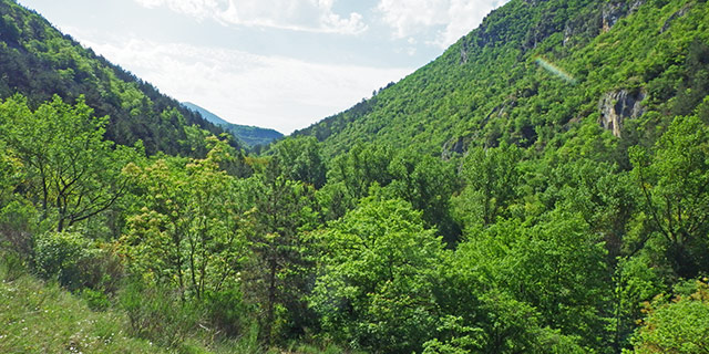
DOWNLOAD MAP DOWNLOAD GPX AND KML FILESThis path along the valley floor is mostly flat, as it follows the Aterno river for 18 km, with an average slope of 3.7% and an elevation of 150m. This easy parth offers evocative views of the medieval villages of the valley, its ancient mills and Roman bridges.
The path partly follows the route taken by Pope Celestine V in 1294 from his hermitage on Monte del Morrone (Sulmona) to L’Aquila for his coronation; a reminder of his journey is the little church of Santa Maria della Sanità in the village of Acciano, where it is said the saint performed a miracle cure. Opposite the church there is a picnic area and an ancient mill that has been restored.
Along the path there are many other ancient mills and the Roman bridges at Campana, Fontecchio and Beffi, all built during the reign of Claudio (C1st). Near the path there is also a series of buildings of historical and architectural importance including: the church of the Madonna della Vittoria at Fontecchio, that of Santa Maria Silvana at Beffi, the tower of Goriano Valli and Beffi Castle.
Also along the path detours are possible (and signposted) to the pagliare of Fontecchio, Fagnano and Tione, and also to the villages in the area where bars and restaurants can be found. From the stations at Acciano, Beffi and Fontecchio you can return by train to Campana.
Nature
The Aterno river is flanked by willows and poplars that form a tunnel along the river. Grey herons, ducks, white-throated dippers, wagtails, and green and great spotted woodpeckers populate the river and its banks. Wild boar, red deer and roe deer can also often be seen. From the bridges we can also see the rich aquatic life.
Once past the station at Beffi, the river passes between two steep wooded banks, interrupted here and there by limestone walls with dramatic rocky pinnacles. On the section between Campana and Fontecchio the remains of ancient terraces can be seen, retained by dry-stone walls, and heaps of stones known as macerine, the result of the clearing of stones from the fields. Now the valley appears to be predominantly wooded, but once it was intensively cultivated and much of the land along the banks was used for growing produce.
 Italiano
  English