
Duration: 1h30’ one way, 2h45’ return
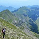
DOWNLOAD MAP DOWNLOAD GPX AND KML FILESA 4.5km walk with an elevation of 170m. The route follows footpaths and tracks that are easily passable. Along the walk you will find the Fonte Ju Puzz, an ancient drinking trough, further on there are beautiful views over woods and fields.
On arrival at Bominaco there is a café/restaurant for a stop. There is also a beautiful medieval fort, the Romanesque abbey of Santa Maria Assunta (C12th) and the Oratorio di San Pellegrino, with its magnificent cycle of C13th frescoes.
From Bominaco you can continue to the villages of Opi and Ripa di Fagnano, or in the other direction, to Prata d’Ansidonia where you can visit the ancient Italic-Roman city of Peltuinum.
Nature
The first section of the path is bordered on both sides by broom, creating a green corridor. When the path levels out, on the left there is a great heap of stones: it is one of the many macerine created by removing the stones from the fields when they were cultivated.
The drinking trough, “ju Puzz”, that we come across immediately after, is home to the Italian newt and the crested newt and nearby a small pond has been created to encourage reproduction.
On the high plateau, before reaching the Cippo pass, there is an area where juniper grows in abundance and there are wild orchids and birds such as the cirl bunting and the common chiffchaff. Then, before and beyond the pass, the path passes through woodland of downy oak, flowering ash, hornbeam and maples with an underbrush still rich in juniper.

 Italiano
  English